Local Distractions

This is the time of year when there is weather, vacations, and lots of food. In my book, these are all valid reasons to get out of the house whenever you can so that you don’t go hurt the ones you love and/or drown your misery in cookies/ pack on the pounds. It is also the time of the year when the hills in northern California become spectacularly green and the air is clear and crisp. With all of this in mind, here are a few suggestions to see something a bit out of the ordinary, if only for a few hours between the rains. They are listed in no particular order. Some are all day activities, others only take a few hours. All are great with kids but are not kid-specific sorts of places. In other words, if you get an afternoon sans the kids, check them out too.

GHOSTTOWNS AND MINING AND CAVES, OH MY!  –  Black Diamond Mines Regional Preserve

$5 parking, $5 mine tour

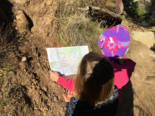
150 years ago there existed 5 towns within the confines of this gem of a regional park. All were associated with coal mining in the eastern foothills of Mt. Diablo. At the time, it was the regional epicenter of commerce and activity. It’s hard to think of a town with a population of 1000 as a metropolis but that is exactly what it was. Yep, that was truly a wilder time. Today you can hike any number of scenic trails into steep, grassy canyons, explore the remains of a town or two, visit a pioneer cemetery, and even go inside a mines and caves. See my earlier post about Black Diamond Mines if you want.

If you can, try to schedule your visit to coincide with the Hazel-Atlas mine tour. (It’s seasonal so call ahead, $5 per person tour fee.) On the 90 minute tour you will go deep into a sand mine. Yep, they mined sand here, for an Oakland glass company. That is just one of the many very cool historical and geological tid-bits that you’ll pick up along the way.

It’s best for the winter months when the weather is cool and the hills are green. In the summer it is blistering here. The downside is that mine tours don’t happen in the winter. However all the guides and rangers we encountered were eager to show something interesting to the kids and they have yet to disappoint. Three trips so far to this park and we are just getting started.

Side Note: For an interesting drive, continue east on 4 past Antioch and head into a bit of the San Joaquin Delta. Just the bit from Antioch to Stockton will give you a taste of what this wider area might have looked like during your grandparents’ youth.

WATERFALL WILDERNESS  –  Sunol Regional Wilderness

$5 parking

This park is great all year but is especially wonderful when the rains start to fall. First of all the drive there is a treat, taking you back into lands you never knew existed. Then there is the amazing rolling topography, complete with grazing cows, wide vistas, curious rocks, and loads of wild flowers. BUT the biggest reason to visit this park in the winter is the Little Yosemite area of the park. Think water roaring over smooth boulders, deep pools of crystal clear water, mountain meadows (toward the upstream side), and tons of great nooks for snacks and picnics.

If you like mud, this is also a park for you. When it rains, the trails can be quite messy, especially when the cows are nearby. Did I mention the open grazing within portions of the park? We had one curious Bessie follow us for a bit last February. The distraction kept the kids going for at least a half-mile between snack breaks.

Depending on your crew and their taste for adventure, the straightest path to Little Yosemite Valley is less than a mile long, along a fairly flat and level gravel road. For something more heart-pumping, you can combine a number of trails to extend the journey as long as you wish. I suggest a longer journey as you wander to the falls, then taking the short and straight path back. After the roar of the water and the thrill of climbing over boulders, hiking becomes much less fun. (The kids are tired and the parents are tired of hearing them whine.)


OLD SCHOOL, SO COOL  –  Mt. Hamilton/Lick Observatory

Visitor Center and Book Shop open Thursday-Sunday, 12-5, and the entire week between Christmas and New Years

This site holds so many personal delights for me. The scenery is gorgeous. It is historic. It is very science-y. And it reminds me of the few special times when I was one of those astronomers, sleeping in a dorm and eating lunch at midnight. It’s a story for later but observatories are special places. They just are. Period.

It’s historic and one of a kind. It was first completed in 1888 when San Jose truly was 30 miles away and light pollution was something no one had thought of just yet. Back then, buildings had ornament, and the architectural design was as aesthetically pleasing as it was functional. The Lick Observatory is a prime example. (It has been evaluated multiple times for inclusion on the National Register of Historic Places but does not appear to be officially recognized as a historic resource. It’s time to make it official, folks.)

The complex sits on the top of Mount Hamilton at an elevation of just over 4,200 feet. This makes it the tallest peak in the Bay Area and a frequent bucket list entry for local cyclists. The drive there goes through park and ranch land, winding ever so slowly up a reported 365 narrow switchbacks. It might not be good for those prone to carsickness or for faint-hearted drivers. For everyone else it is a bit thrilling and quite beautiful.

The trip up to Mount Hamilton and the walk around the grounds is a great day-trip. There are frequent talks, numerous displays, and occasional special programs that bring the modern science of astronomy within reach of the average curious mind. The views alone justify the 1+ hour drive from San Jose.

A word of warning though. Get gas and food before you start climbing up CA 130. There are no gas stations and the “café” consists of vending machines and a k-cup machine for hot drinks. So prep accordingly and you will be perfectly prepared to throw caution to the wind and try the 2-hour drive down the back side on CA 130 east to Livermore. WOW! Let me repeat that. WOW! This road can’t be believed. If you love exploring, and driving, and feeling a bit lost in the best possible way then take this drive. Also, it is not for those prone to car sickness. You’ve been warned.

dunsmuir
Dunsmuir Park – house and part of the grounds – June 2016.

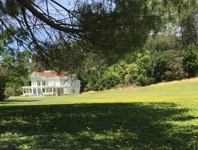
SHORT AND SWEET  –  Dunsmuir House

Grounds open Tuesdays – Fridays, 11-6 pm except on public holidays. House tours are offered April – September at 11 am – $5 for adults. Call for special event hours and pricing.
Parking is free but limited.

This is a City of Oakland park at the southern end of Oakland, just off 580. It can’t be seen from the highway and signage is a bit lacking, and that is what makes it feel like a secret find. Park along the street near the East Bay Regional Parks Headquarters and walk through the iron gates onto the landscaped grounds. Portions of the park feel lush, like a private garden from story books. Other parts of the park have a more, well, abandoned, Secret Garden, sort of feel. A paved drive/path wanders through the landscape, bringing you past a pond, a blindingly bright white mansion, ruins of a former pool house, and several other areas both modern and original to the estate.

Built in 1899, this grand estate was a private residence until it was purchased by the City of Oakland in the 1960s. Now the 50-acre property is a public park with special holiday events (Easter egg hunt, Christmas tea, etc.) and available for weddings. The building itself has been featured in several movies. My favorite is So I Married an Ax Murder (1993) where it served as their honeymoon destination – The Poet’s Corner.

What is nice about this park is that once you are on the grounds, it is like stepping back in time. There are views only of the little valley in which the park sits – no highways, no modern buildings, no houses even. There is ample shade and easy access too, perfect for a picnic, for lounging quietly, or for little ones to run and play in the wide grassy lawns.

Don’t expect tons of benches or water fountains or other sorts of amenities that might be found at a typical city park. This still appears as a private estate, only one that you can visit for free provided you can get there during their somewhat limited hours. Plus, it is super close and just a little bit unexpected.

LAND HO!  –  Bay Area Ferries

Oakland to San Francisco is $6.60 each way for adults or $5 with your Clipper card. Kids are half that.

Not sure what you want to do other than get out of the house and experience something different? Take a ferry. They run from all sorts of locations, most have parking nearby (but be sure to check on the commuter lot rules/hours), and some even serve food and drinks on board. Why drive to San Francisco when you can motor along on the water? It makes the journey magical and it gives a whole new perspective on old familiar landmarks. Plus you can relive the glory-days of ferry travel before the bridges were built.

For example, did you know…

  • The San Francisco Ferry Building handled over 100,000 passengers per day before the Golden Gate Bridge (1937) and San Francisco Bay Bridge (1936) were completed.[1]
  • At its height in 1930, 43 ferry boats operated between the two sides of the bay.[2]
  • Getting from Oakland to San Francisco by ferry takes approximately 30 minutes.
  • You can take a ferry to see the Giants play baseball.

Personally, I recommend leaving from Jack London Square in Oakland at sunset and returning after dark to see the lights on the Bay Bridge for a no effort, very romantic (hint hint) date night. It also works for cranky kids, especially if you throw in dinner at the Ferry Building or at Jack London Square to sweeten the deal. Not the cheapest outing but it is definitely unique and it requires no planning.

There are ferries to/from Fairfax, Sausalito, Vallejo, and other points. Seasonally they run to Angel Island from the East Bay, or year round from Tiburon. The point is that they go more places that you might think.


There are so many distractions in the Bay Area that sometimes the hardest thing is to pick just one. Hopefully some of these are surprises and inspire a sense of adventure and curiosity for this amazing place to call home. We can all use a bit more unexpected wonder in our lives, particularly at this time of the year. Enjoy!


[1] San Francisco Ferry Building National Register Nomination, 1978.
[2] Website: A Brief History of Ferries on the Bay…


Chinese Camp

On the way to Yosemite there is a town that hovers right upon that breaking point between ghost town and hamlet. If you drive on Highway 120 you will never see more than a historical marker and perhaps a cool, plant-hidden, maybe-occupied building. But if you stop to walk around, you will find a handful of unoccupied buildings, a few ruins, and neighbors working in their yards. This is Chinese Camp.

img_5164-marker

The sign dates to June 19, 1949 and reads:

Chinese Camp

Reportedly founded about 1849 by group of Englishmen who employed Chinese as miners. Much surface gold found on hills and flats. Headquarters for stage lines in early 1850s, and for several California Chinese mining companies. First Chinese Tong war in state fought near here between Sam Wap and Yan Woo Tongs. Present stone and brick post office built 1854, still standing. St. Francis Xavier Catholic Church built 1855, restored 1949. First pastor, Father Henry Aleric. 

Actually, most settlements had a sizable Chinese population, many with a “Chinatown” section toward the outskirts of town. This one is unusual in that it was named for this typically mistreated group and there may be more to its significance than the sign and popular histories indicate. To say that the Chinese settlers were treated roughly is an understatement, but we will leave that for a future discussion. The point here is that they did much and are typically left out of the histories except as footnotes where mining and railroad construction are concerned. Make no mistake, however, there would have been a very different gold rush/rise of agriculture/late-19th century in California if it were not for the hard working immigrants from China and its neighbors.

As for the current town of Chinese Camp, it provides a satisfying stop to stretch your legs. Just past the historical marker there is the ruin of the Bruschi Store. It is partially occupied by a modern metal shed, but this ruin seems to have been ruined for much longer than it was a store.

Across the street is a wood frame house that has also seen some changes. Note the two-story porch. Today it is a bit more modest.

A few steps further down the road is the old post office. This is the building referred to on the historical marker along Hwy 120. It seems it was periodically opened to the public up until at least 1993, but now appears permanently shuttered.


Next to the post office is a building noted as the Rosenbloom Store in the 1948 DOM book. Its roof has changed, and it lost a wall or two along the way, but the façade remains.

You may notice pairs of green, metal shutters on the brick-front buildings. These metal, often iron, shutters are a common feature throughout California’s gold country. Window glass was expensive and fragile in the 19th century. Therefore, it was limited to small panes (think gridded windows on old houses) and used sparingly on the frontier. When the goal was to build cheaply, quickly, and securely, and to avoid being burned down in the frequent fires that swept through town, stone, brick, and metal were the best choices. The stone was quarried nearby. Brick was expensive so it was used only on the important parts (fronts mostly). And any openings were secured with metal shutters, typically painted green. The shutters made it difficult for unwanted visitors as well as fire to plunder the building.

Two other buildings of note on this small stretch of street are on the opposite side of the street. The first is a one-story, false front building. Stepping back to view the side wall of this structure, it is hard not to be impressed with the audacity of the designer. They took the concept of false front to its extreme here.


false-front
False front buildings were very common. Here 3 stone walls are exposed and the front is covered with wood siding.

The other is at the intersection with the rest of town. This wood frame, two-story building appears to have once been a hotel or boarding house. It is architecturally more ornate than the others with carved window trims. Such tactics were employed to suggest a respectable, more high class sort of establishment. Whether this was the truth or not I have not been able to discern.

hotel
This building is likely a former hotel or boarding house, based on its size and architectural styling.

Here is a website with photos from 1993 and scans from a 1971 book showing many of these same buildings.

There are other structures in Chinese camp, scattered amidst the homes and modern establishments of the current residents. It was beginning to rain so our trip was limited to this one, most easily accessed, street directly off 120. On a future trip I plan to see a bit more of this once robust town. If you are in the area, it is worth a few minutes detour.


Note: All references the Department of Mines 1948 book (also noted at DOM 1948) officially refer to Jenkins, Olaf P. State of California Division of Mines Bulletin 141: The Mother Lode Country: Geologic Guidebook Along Highway 49 – Sierran Gold Belt, Centennial Edition. San Francisco: State of California Division of Mines, 1948.

Workin’ in a coal mine…

I love parks. I have said so many times and working in dozens of local, regional, state, and national parks over the years has only increased my love of, and respect for, our parks. So it is a special treat when I get to explore a new one and find it is so much more than I expected. Black Diamond Mines Regional Preserve is one of those treasures.

Black Diamond Mines Regional Preserve has been on my radar for a long time, but it is also a decent distance from my house (an hour or so with normal traffic.) As a destination, this park had to really wow me to make me want to come back. It delivered. Two trips in and I can’t wait to go back.

First of all, the topography is enchanting. Unlike the rest of the lovely rolling hills in the East Bay, this park is has steep hillsides and narrow, tree-lined ravines. Driving into the park you immediately leave modernity behind and see nothing of the rest of the world. It’s totally immersive.

BDM1

Black Diamond Mines Regional Preserve encompasses an area that was first mined for coal in the 1860s. At the time it was one of the most populated areas in this part of California. Five towns once existed within the mining district. Then in the 20th century, after the coal mines closed, sand mining began. The sand mines were way more extensive than the coal mines, but both resulted in numerous shafts throughout the area. Most have been sealed for safety but a few have been gated for the curious to peer into. There are a number of books on these periods of development and the park has interpretive materials throughout as well.

We have now made two trips to explore the park. The first was New Year’s Eve day last year. I went with my two kids and a friend who brought two of her (now) four children. (The kids ranged in age from 4-8.) After a warm-up snack, the kids surprised us by rushing up to see Rose Hill Cemetery. It is hard to miss. Just look for the tall Cypress trees on the hills above the parking lot. Once there, the questions got real pretty fast when they spotted the graves of children. Teaching moment – life was pretty hard in the 1860s.

BDM2

Not letting a thing like death or sickness dampen the day, we had another snack break then headed back downhill to follow the self-guided tour. It lead us from one mining-related site to another, including caves, mine shaft openings, a (sadly closed) visitor center INSIDE the mountain, and a railroad spur. After two hours of climbing over sandstone trails and peering into gated mine shafts, they were ready for a final snack before heading home. I stopped at the open visitor center near the entrance on our way out. It was a quiet day and I think the ranger was glad to have someone to talk to. Lucky for him, we love to ask questions. When my son asked about the snake in the aquarium near the corner, the ranger took it out for him to hold. He was in heaven. We left there with a bag of coal, two free 2015 Trails Challenge t-shirts, and a vow to come back when the mines tours were open.

That leads me to the second trip a few weeks ago. The park staff operates guided tours of the Hazel-Atlas sand mine from March through November. Apparently it is too cold in the mine the rest of the year for them to comfortably run tours. Anyway, for curious bodies 7-years old and up, you can pay a nominal fee ($5 for the tour we took) and enjoy a 90-minute stint in the mine. (Snack it up before the tour. No eating is allowed inside.) It normally starts with a presentation in a theater they wired in an excavated area near the entrance. Yep. A theater. In a mine. The projector was on the fritz during our tour so we got a low-tech version of the presentation outside. After that you get outfitted with a hard hat (like a real miner) and grab a colorful flashlight from the rack near the theater. If you are cold they have jackets too. This sounds silly until you realize that for months of the year the outside temperature is 90+degrees while inside it stays in the 50s.

I won’t spoil all the fun but you do get to see coal seams, an earthquake fault, ancient sea fossils, vast caverns, and real mining equipment. Our tour guide was AMAZING and clearly loved his gig. My son was enthralled from the point when he could touch the earthquake fault. My daughter was less into it but was still a good sport. My husband said it was one of the best tours he has ever been on, and he is a hard customer to impress.

Then, on our way out, another ranger had a table set up near the parking lot to educate folks on the native tarantulas that live in and around this park and Mount Diablo in general. He had 2 male spiders, both larger than I would hope to see on a hike. They were apparently rescued from near the edge of the parking lot. Yikes! We learned lots about them, including that they were likely 7 or more years old and that they were both going to die in a few weeks. There were also some delicate conversations around spider mating as well, so it was an education for everyone.

Now it’s time for another visit. Apparently you can hike to the remains of one of the mining towns, like discovering your own ghost town. This is definitely a place best hiked in the cooler months as the tree cover is minimal and this part of the Bay Area can be brutally hot in the summer. Still, there is so much to enjoy at this park, both natural and historical that just about anyone could find something of interest.

Just bring snacks. And watch out for giant spiders.

Details:

Black Diamond Mines Regional Preserve is located approximately 4 miles west of Highway 4 in Antioch. Parking fees apply. Call ahead for mine tours and visitor center hours. The parking lots have restrooms and water but plan to bring water with you if you hike much beyond the parking lots. Mine tours run March – November. September is the best time to see tarantulas.

A Little Detour

I have always been interested in local history. It is the primary reason I went into historic preservation as a career. In that capacity, I have encountered fascinating bits of hidden history throughout California that make my journeys through the state rich, sometimes odd, and always interesting. In conversations with friends, it seems I am not the only person who enjoys this sort of connection with the places I visit.

1948_motherlodebook
1948 Geologic Guidebook to the rocks and things made with rocks along California’s Highway 49.

Now a while back I encountered a book published in 1948 by the California Department of Mines (DOM.) Back then the DOM still carried a small responsibility for promoting the geological and natural wonders of the state. (You should read this recent book compiled from William Henry Brewer’s reports from the 1864 expedition when the high peaks were named. WOW!) Anyway, the 1948 DOM book takes a fabled route – Highway 49 – and catalogs the many different towns, settlements, and ghost towns along its length. Granted, the authors are mainly concerned with stone construction within these settlements, but they share bits of history, including dates and names, for each of these places.

While working in the gold country this 1948 book, published purposely on the centennial of the famous discovery of gold in Coloma, provided a snapshot of a very different California. While it chronicled what remained after decades of neglect, there were still many traces of the gold rush period left untouched, pristine in their decay. The population boom and development pressures of the post-World War II period, the money and expansion of the dot com bubble, and the rise of McMansion and retirement communities were still in the future. When that 1948 book was written there were still people around who lived during the Gold Rush.

1949map
1949 promotional tourist map for Highway 49 – the Golden Highway (David Rumsey Collection).

Fast forward nearly 70 years and things have certainly changed. Some of the 1948 towns are 2016 ghost towns. Many of the 1948 ghost towns are remembered only as historical markers on the side of the road. In spite of the passage of time, vestiges of that mythical California remain. If you know what to look for, you can find them all over. And that is the point – you need to know what to look for and here is where I might be able to help.

It’s a project that has been floating in my brain for nearly 10 years and it is time to do something about it, so I am beginning a little experiment. I plan to visit the places along Highway 49 mentioned in the book and see what remains. I’ve worked in and studied many of these placed and where I can, I’ll pass along the things I’ve learned. Many stories surround the gold rush. Some are true. Many are not. I will also do my best to note which are verified truth and which are popular fantasy. Both have their place on this journey.

There are plenty of websites and resources regarding the history of this area. I am not attempting to recap all of that, but to be more precise about the specific buildings and sites that are found along the way. As an architectural historian, I love old pictures. Where possible those will be included. Everyone loves then-and-now comparisons. The discovery of gold and the exploitation necessary for its extraction are one side of the story. My goal is to pay more attention to the people and communities who built (and abandoned) the settlements along the way.

So stay tuned and let the adventure begin…


Junior Rangers

Spring break was last week and luckily it happened to coincide with spring-like weather. This result was a relatively peaceful family camping trip to the beautiful Marin County coastline. If you have never explored this part of California, you should. It is compact, diverse, remote-feeling and yet still accessible. And best of all, there are many wonderful food and lodging options if say, sleeping on the ground with neighbors unknown and sharing bathroom facilities is not your thing. I’ll warn you now though, camping is a great way to experience this spot and I am partial.

Redwood Cathedral

The campground at Samuel Taylor State Park is about as easy a way to be in the redwoods as you could imagine. Apart from its clean, well-appointed, and shaded campsites, there are miles of paved bike trails and more miles of hiking trails that run around the camp. This year we were also treated to the gurgle of a well-fed stream and the chance to spy baby salmon. (We did not see any but the hunt kept the kids entertained.)

This alone was great, but the reason I chose this park was its proximity to Point Reyes National Seashore. Camping in Point Reyes is hard to come by and there are no drive-in campsites. This is a deal breaker for us so we opted for a lovely 6-mile drive between Sam Taylor and the Bear Valley Visitor Center.

A word about the visitor center – Go there. Walk the Earthquake Trail. See the recreated Ohlone Village. Tour the small but thorough displays on the flora and fauna of the area. The park rangers have loads of information on trails, activities, and general recommendations on all things nature-related. The bookstore leans more toward books (shocker!) and field guides than toward souvenirs. Best of all, they are the source for Junior Ranger booklets.

I was turned onto the program by a friend, who traveled through the Zion-Bryce-Grand Canyon area with her family. Never will I visit a National Park without picking up materials so my kids can participate. You get a booklet that has information about the history, geology, ecology, biology, as well as a sprinkle of trivial knowledge about park that is written for the average fifth grader to understand. This translates to a bit of parent involvement but it is worth the effort. Sprinkled throughout the booklet are activities to guide kids while they are in the park and areas for the kids to record their experiences. Once they complete it, they return to the visitor center to have their booklets inspected or to answer some questions (a mild test to be sure). Then they are “sworn in” with an oath to protect the park as Junior Rangers. For their efforts they receive a special iron-on patch. We collect patches in our family so this was a coveted prize.

Oh, and it’s all free.


You might think that having homework to do on a hike would betray the whole point of being out in nature, but that did not happen. Instead it turned a trip that would usually be fraught with are-we-there-yets and how-much-longers and I’m-hungries into a scavenger hunt. We heard is-that-a-buckeye and I-found-3-kinds-of-flowers as well as I’m-hungry. My daughter took a row of pictures in her booklet and added check boxes so she could mark her finds. My son begged for me to record his finds with my phone camera.

Back at the campground, they worked, with help, on the word search, a crossword puzzle, or drawing pictures to illustrate the answers to their questions in the booklet. My daughter had to bring it into school for show and tell. She wrote three entries in her kindergarten journal about it. My son made connections between the Ohlone information he read in the booklet and learned at the visitor center with the lessons his 3rd grade class has had throughout the year.

They made connections to place that were larger than a single hike and longer than a few nights camping. There was pride in their accomplishments and an eagerness to explore further. We will return, with friends, so that others can see this amazing place and maybe earn their own badges. Regardless, pick up booklets for your kids. Read it with them if needed. If we can get this generation engaged, our National Parks will be even more special when they turn 200.

My only regret is that we did not have one more night at the campground for down time. After the hike, the kids went into the tent and did not emerge until dinner. One fell asleep. The other made a nest of sleeping mats and blankets and rested his sore feet. After all, one of the best parts of camping is relishing the delicious exhaustion of a day spent exploring the outdoors. Sometimes doing nothing is the best way to experience the world.

IMG_0607


Trial Run – Pinnacles

Back in January, with 10 days worth of wear on our new vehicle, we set out to test it on a road trip. The destination was Pinnacles National Park, about 2.5 hours south of us. This National Monument-turned-recently-National Park (2013) is known for many cool features including bats, caves, condors and for being split by the San Andreas Fault. It is half of an ancient volcanic field that traveled north 195 miles from its source. The result is towers of basalt rising up to form narrow canyons and a landscape so wholly different from the agricultural lands around it that is seems alien.

The weather was touch and go but we decided to make the drive anyway and take our chances. In the winter, access to the caves is not guaranteed. One set was partially closed for bat protection, so we drove to the lesser-used west entrance to take on the Balcony Caves.

On the ride down we played with the satellite radio (something new for us) and tested the navigation controls. (The adaptive cruise control is the best feature EVER.) “Are we there yet?” rang out about half-a-dozen times and from only one mouth in the back seat so, it was all good.

Balconies Cave Trail
Starting out on the Balconies Cave Trail – Pinnacles National Park

Once we arrived at the park, we first paid our entrance fee and explored the new visitors center at the west entrance. The kids picked out the items they had to have and we distracted them with thoughts of lunch. It was overcast and warm – perfect hiking weather. The bonus was the rains that pelted most of northern California during the prior week left the streams with running water and the plant life green and inviting.

From experience we knew that pleasant hiking with our children required a pack of snacks and as much possible distraction as possible. Purposely, I held back on some of the items I packed for lunch and recategorized them as snacks. You just never know. Distraction, however, was all around us. The trail was relatively flat, following a narrow canyon between towers of rocks and crossed by a small stream. Rarely could we see more than 50-yards ahead as the trail wound between massive boulders or turned around isocracies in the landscape. The kids wandered ahead of us to discover tiny waterfalls, shallow caves, or various interesting trees.

As we stared to climb over the caves on the trail, my son spotted a small bit of color on the rocks across the canyon. Rockclimbers. From where we stood their ropes were invisible. Real life spidermen (or women, we couldn’t tell) were scaling the face of the rock. We stopped for a snack break and watched. Then we made way too much noise because the echo was amazing in that narrow canyon.

IMG_0376

Near the half-way point, still wondering what’s around the bend.

After a couple of miles, we had hiked up and over the caves, and were now ready to enter them as part of our return journey back to the car. The kids donned headlamps and ate another snack, while my husband and I pulled out a couple of flashlights. Now the trick was finding the trail. We knew we were near the caves. The ranger we passed told us. The gate and the many signs warned us as well, but still, there was only a stream running through openings in the rocks. Huh? I guess the stream is the trail?

Just then two men came out from the rocks, trying to avoid getting wet in the stream. Yep! Through the stream. The first casualty was my son. Splash. Wet shoes. He thought it was funny and it was. We climbed, jumped, and lifted each other over the rocks and water, eventually finding the true entrance to the caves.

Thank goodness for the headlamps! The scrambling was no joke and I marveled at the large families with small children making their way through in the direction opposite from us. Most had no flashlights or at best 1 or 2 poor excuses for flashlights. As my 6-year old daughter struggled to climb I watched 2 and 3 year olds being handed down wet rock faces by pre-teens or dads in jeans and t-shirts. Still, they were having a good time and so were we. Until my daughter missed a step. Casualty number 2 – wet and scraped up.

IMG_0384
Final snack break.

After climbing up, we entered an open area and there appeared railings to help us with the climb down. The water was not as prominent here but the walls were much closer together. Being smaller, the kids were faster in this section than the adults. Before we knew it, we were back in the light of the canyon, re-tracing our steps on the dogleg back to the parking lot. We stopped for a few more snack breaks along the way and sat to watch others emerge from the caves, or wind their way along the trail.

Heading out, the kids got patches for their collections, and the car got a National Parks Passport to help record future adventures. We also added a pack of playing cars with the constellations and facts on them. As the rain began to pelt the highway on the way home, the kids played cards and we only heard “Are we home yet?” 2 or 3 dozen times. Why can’t they just fall asleep back there?

Around the next bend

Sometimes the world seems big, expansive, overwhelming. Sometimes it feels too small for comfort, too familiar. The one thing it never is, is boring. Whether you look closely to discover something you never noticed before, or pan back to take in a sweeping vista, there is always something new.

But that new thing is easy to miss in the details of everyday living. We have to be here at 8, there at 2, practice at 4, meetings at 7, bedtime. Repeat. That might be what many days look like, but it is not what we will remember twenty years down the road. What we will think back on and smile about are the tines when we were NOT following the routine. Our view of the world is shaped by those times when we open our eyes to something new.

I’m not naïve. I do realize that my children will eventually come to humor my attempts to expose them to the variety of the world. Perhaps they will do so with a knowing smile. Or maybe they will go kicking and screaming. Maybe they will opt out when they are old enough to know what that means. However I have the grand vision of family togetherness playing on repeat in my head. Reality be damned. I will try to broaden a few horizons or at least plant the seeds of appreciation for being outside of your own head, in the world, in the moment.

So, in an effort to do this, we bought a vehicle made for exploring and christened it, UTFRSKA. To be fair, it was time for a new car so the exploring part was not our only motivating factor. However the Swedish pedigree of the car did influence the license plate and now we are ready to hit the road for adventures big and small.

Utforska = Explore. We did verify this first with an online translator, then with a couple of real live Swedes. Hopefully they weren’t just being nice because we already ordered the license plate.

Irrational numbers

Just when I think the directions are clear and I know where I should be going, I feel lost. This can be said of my writing these days as well as in life. It all makes so much sense from the big picture view. Yet when you get into the details and try to figure out how they might possibly fit together, it all gets fuzzy. The more you know, the less you know. You know?

In the first semester of my sophomore year in college I took Physics 212. Until then I thought I knew math. Two weeks into that course I realized I knew nothing. We worked with integrals that only approached a limit, but never actually got to their end destination. Instead of equaling an actual number, they just got smaller and smaller forever but the sum of the rapidly diminishing solutions was only an approximation. It was deeply unsatisfying. How can a solution not actually be the real answer and how could that possibly be useful? I had to just accept the concept and move on even though I did not understand the underlying theory. I still don’t.

What I should have realized then is that math is always the simplest way to say anything. What better description for the way life really works could there possibly be? We can see the answer, the end goal, the gate to Nirvana, but we can never actually get there. And the closer we get, the farther the journey seems. Just trying losing that last five pounds of baby weight and you will understand what I mean.

Part of the joy in historical research is getting lost in the detail. Each piece of information leads to another idea, another fact that leads to another, and another, like an endless trail of breadcrumbs. Each individual element is interesting, titillating in its own way and feels like a treasure, but it is so easy to amass a great pile of facts and forget the actual reason for researching. Giving into the search and losing one’s bearings, just a little, is when the best material comes to light. That is why it is so hard, and a bit disappointing to get back on track and take the big picture view. Sure it makes more sense, but it lacks adventure.

So right now I am awash in dates and details, character flaws and chapters with no ending. I am more lost than I care to be. I cannot seem to step back far enough for a bit of clarity. A good part of me wants to move on, pick a new subject and be a bit reckless. The rest of me is hoping that, like Physics 212, I can trudge my way through the diminishing returns and reach a point where I can approximate a solution.

At the end of that semester I was no longer thought I knew a thing about math, but I did understand more fully what I was capable of doing. Even now that C that I earned is one of my prouder moments. I hope at some point I can look back at this period in my life and say it too was one of my better endeavors.

Starting Somewhere

I’m a fairly practical person, or so I tell myself most days. I try to reason through life, using logical approaches, common sense methodologies, and generally trying to be fair and just. However, I am realizing more and more that this is really my own perception of what is fair and just within a reality that only exists in my head. What I see as a natural outcome may seem completely irrational to someone else. My clearly delineated, step-by-step decision making process may seem perfectly convoluted to you. Coming to this realization has changed my perspective in a major way. It’s brought a new awareness that is, for me, exciting and engaging in a way beyond facts and figures. And don’t get me wrong, I love a good fact and drool over juicy figures. But this is more personal and more difficult to comprehend. It’s a challenge that will never end and that is what is so exciting; it is limitless possibility. It’s my own personal reality.

Until recently, I worked as a historic preservation professional. In this line of professional work, the idea that a place has an identity, like a person, is fairly commonplace. Generally it is not related to a stated slogan in a tourist brochure (welcome to the Lemon Verbena Smoothie Capital of the World everyone) it is a sense of place that is almost intangible. Truly authentic places envelop you in a unique identity that you can sense but perhaps not fully describe. It’s made up of history, people, events and the interconnection of these things to larger histories, people, and events in other towns, maybe in other states or areas of the world even. Each connection may be shared with another place, but the collection of connections is unique. We try to understand this sense of place through development of a historical context that identifies the major historical themes, important people, and influential events for a place and the connections that these elements have to other places. Contexts are never simple, but they are essential to developing programs and methods to protect and celebrate the uniqueness of each community.

People too have their own contexts. They each have a unique history, encounter different individuals, have adventures and tragedies, and experience life in different ways. Each moment shapes how we see and interpret the next. It’s a combination of nature and nurture. We are each born with an individual brain and hardwired with neural connections that can predetermine some aspects of our personality. My son is a morning person. Always has been. My daughter is most decidedly NOT a morning person. Never was. It has nothing to do with our morning routine or any particular approach to starting the day in our household. It doesn’t matter where we are. He will wake up first and she will linger in bed until hunger forces her into the kitchen. Hardwired. But we add to these differences the experiences and emotions of our individual lives. The result is a construct of the world that is all our own. We really do live in our own little worlds.

The first sense of the power of perception I had was when I learned about the physiological factors that dictate our interpretation of color in Biology 101. Wavelengths of light hit the back of our eyes and are detected by the nerve endings in our retinas. This sends a signal to our brains. Variations on the signal are interpreted as various colors. But if you are color blind, you don’t see certain colors. The kicker is that you don’t know the difference until something causes you to question your reality. Taken to a philosophical extreme, who is to say that what I call red, what I have known my whole life to be the color red, isn’t somehow green to you. We may both call it red but what we actually mean by that term could be quite different. I’m coming to understand that life is like this in so many ways: we say the same thing but mean something very different.

So in the posts on this blog I want to explore some of the things that interest me and the connections that I make to other things that interest me. Maybe it interests you too. Maybe it’s a waste of your precious time. In either case, you will have learned something new, so on to the adventure…